The Land of Israel
This map is available as a high resolution digital download with detailed instructions. You must bring the file to an Office Depot or similar store for easy color print and lamination. For personal, church or classroom use only.
Deuteronomy 26:9 - "And he hath brought us into this place, and hath given us this land, even a land that floweth with milk and honey."
FOLLOW THE MAP
The Land of Israel for Little Kids

This map shows some of the key places and topography of the
land of Israel during ancient times! Israel is known as "The Promised Land"
because God promised it to Abraham and his family. The land of Israel was
located in the center of the ancient world, but it wasn't very large. The
distance from the city of Dan in the north to the city of Beersheba in the south
is only about 150 miles. That may sound big, but really the whole nation of
Israel could fit in the United States over 450 times!
Something really cool about Israel is all of the different landscapes. Along the
coast by the Mediterranean Sea, there are a lot of flat plains that were perfect
for growing plants and food. In these areas you could find all kinds of things
from flowers, to fruits like oranges, grapes and lemons, and grains to make
yummy bread. When God told His people about the Promised Land of Israel, He
described it as a place "flowing with milk and honey," which means it would be
very good land to grow plants and food.
When you travel further into Israel, you reach the Foothills and Hill Country.
Foothills are small hills, but next to them in the Hill Country were big hills.
Some of these hills are talked about in the Bible like Mount Gilboa where there
was a big battle.
Beyond the mountains of the Hill Country is the Jordan Valley, where the Jordan
River flows. At the spot where the river meets the Dead Sea is the world's
lowest point on land! That means this is the closest place to the center of the
Earth that you can walk to on ground. In ancient times, this area was very
tropical like Hawaii!
It is good to know these things about Israel so we can have a better
understanding of what it was like when the events in the Bible took place.
Click here to listen if the above player does not work.
The Land of Israel for Big Kids
 Israel
in Bible History. God promised Abraham, the first Hebrew, that if he would
leave his home in Ur the Chaldees (a city near the Persian Gulf) and travel to a
land that he had never seen before, God would bless him and his descendants
would outnumber the sand on the seashore and the stars in the sky. God promised
that if anyone blessed Israel they would be blessed, and if anyone cursed Israel
they would be cursed. But the greatest promise was that one of his descendants
would be the Savior of the world who would bless all mankind. This all took
place around 2000 BC, and the Israelites did not actually enter the land of
Israel and take possession until around 1450 BC. When Moses looked over the land
from the top of the mountain on the other side of the Jordan River he saw the
beautiful land flowing with milk and honey. The Israelites were not fully aware
of how strategic this little piece of land was. This little territory borders
three continents, Asia, Africa, and Europe and is in the center of the ancient
world. If one were to travel from any of the great empires they would pass
through Israel. For example to travel from Egypt to Greece, or from Rome to
Persia, one would have to pass through the land of Israel. God made the Jews His
"chosen" people, who were chosen to bear his oracles (prophecies) and tell the
whole world about God. They succeeded in accurately transcribing the prophecies
and even numbering them to perfection, but they failed in the task of sharing
their God with the rest of the world. Yet God was in control and sent the
Messiah to complete the mission by raising up a church, a band of followers, who
would take the message to the farthest parts of the world. It all started in the
land of Israel.
Israel
in Bible History. God promised Abraham, the first Hebrew, that if he would
leave his home in Ur the Chaldees (a city near the Persian Gulf) and travel to a
land that he had never seen before, God would bless him and his descendants
would outnumber the sand on the seashore and the stars in the sky. God promised
that if anyone blessed Israel they would be blessed, and if anyone cursed Israel
they would be cursed. But the greatest promise was that one of his descendants
would be the Savior of the world who would bless all mankind. This all took
place around 2000 BC, and the Israelites did not actually enter the land of
Israel and take possession until around 1450 BC. When Moses looked over the land
from the top of the mountain on the other side of the Jordan River he saw the
beautiful land flowing with milk and honey. The Israelites were not fully aware
of how strategic this little piece of land was. This little territory borders
three continents, Asia, Africa, and Europe and is in the center of the ancient
world. If one were to travel from any of the great empires they would pass
through Israel. For example to travel from Egypt to Greece, or from Rome to
Persia, one would have to pass through the land of Israel. God made the Jews His
"chosen" people, who were chosen to bear his oracles (prophecies) and tell the
whole world about God. They succeeded in accurately transcribing the prophecies
and even numbering them to perfection, but they failed in the task of sharing
their God with the rest of the world. Yet God was in control and sent the
Messiah to complete the mission by raising up a church, a band of followers, who
would take the message to the farthest parts of the world. It all started in the
land of Israel.
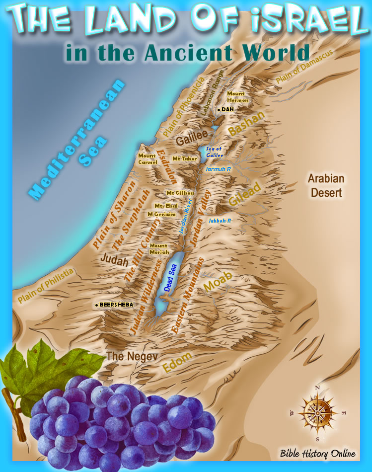
The Land of Israel. The land of Israel throughout history has been the area of land bordering the continents of Asia, Africa, and Europe. The land itself stretches from the city of Dan in the north to the city of Beersheba in the south, a distance of only about 150 miles. From east to west it is only 28 miles from the Sea of Galilee to the Mediterranean Sea. The distance from the Sea of Galilee to the Dead Sea in the south is almost twice as far, about 54 miles. The Land of Israel is much smaller than most people realize.
The Natural Divisions. There were five natural divisions in the Land of Israel which run parallel to each other through the entire land from north to south. The Coastal Plain, The Shephelah, The Hill Country, The Jordan Valley, and the Eastern Mountain Range. Also running perpendicular to these divisions was the Plain of Esdralon which runs from east to west.
The Coastal Plain of Sharon. The Coastal or Maritime Plain was a very fertile region located along the western shores of the Mediterranean Sea. The thin strip of land was nearly 10 miles wide extending about 150 miles from the Plain of Phoenicia in the north to the Plain of Philistia in the south. The Coastal Plain actually was divided into 3 main sections: Phoenicia to Mount Carmel in the north, Sharon in the middle, and Philistia in the south. Centuries of rain from the hill country brought extremely rich soil to the plain of Sharon and along with the warm weather it produced an abundance of flowers, grains and oranges, lemons, grapes, almonds, figs and, on the foothills, olives.
The Shephelah. The Shephelah were the fertile foothills between the Coastal Plain and the Hill Country. Farmers produced lots of crops in the foothills including olives.
The Hill Country. The Hill Country, or mountain region were part of the mountains of Lebanon, and they were naturally divided into four regions: Upper Galilee in the north, below that was Lower Galilee, the Mountains of Judah, and the Hills of the Negeb Desert.
The Jordan Valley. The Jordan Valley, which follows the Jordan River descending into a gorge which continues to descend into the deepest land trench, 1300 feet below sea level.
The Eastern Mountain Range. The Eastern Mountain Range, situated east of the Jordan River were fertile mountains naturally divided into 3 sections: Bashan in the north, Gilead in the middle, and Moab in the south.
The Plain of Esdralon. All of the Plains, Hills, and Valleys go from north to south but the flat Plain of Esdralon actually goes from east to west. You can see this when you are standing on the top of Mount Carmel, and its a beautiful sight to see. It was also referred to as the Plain of Jezreel and in the midst of the plain is a hill called Megiddo. In history whoever controlled Megiddo controlled the plain, and also Israel. Most of the major battles were fought near this hill. The Hebrew word for hill is "har" and this hill on which Megiddo sat was called "Har-megiddo" or the Hill of Megiddo which translated into Greek is "Armaggedon." This then is where we get the Bible's image of Armageddon as the final battle of all of human history before the return of the Lord.
The study of the Land of Israel is very important in the study of the Bible, let's pray:
Dear Jesus, we thank you for Israel, and for the promises that you made to the first Hebrew, Abraham. You told him that if he obeyed you that you would give his descendants a beautiful land flowing with milk and honey. You also promised that the Savior would come out of this land. We love your promises and we love you because you first loved us. In Jesus name... Amen!
![]()
The Land of Israel for Kids
Kids
Map of the Land of Israel for Bible Study
Kid's Bible Maps
Bible
History Online
The Geography of the Bible
© Bible History Online (https://bible-history.com)
Made by Network Local